 Right of Way · Eminent Domain &
Condemnation Consulting Firm
Call or text(469) 484-7960
Emailinfo@nationalrow.com
Right of Way · Eminent Domain &Got a TxDOT letter or a survey request? Call or text (469) 484-7960Status checked October 27, 2026 against TxDOT's own records
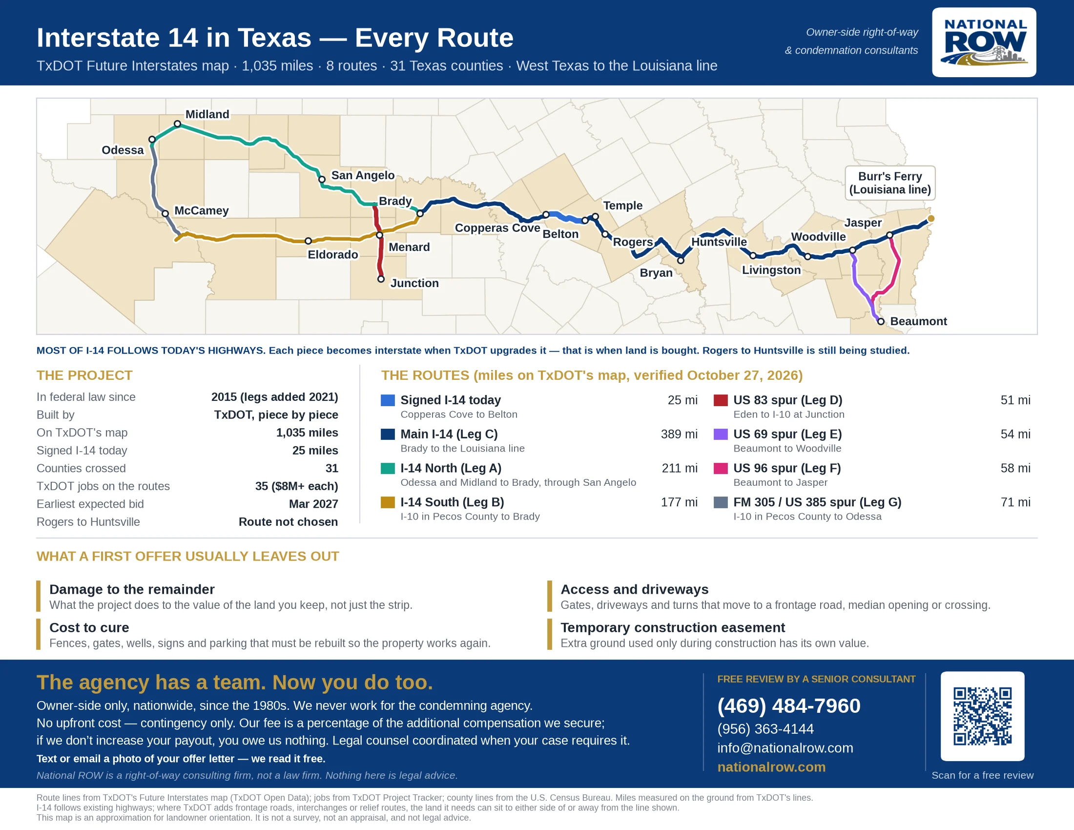
I-14 runs from West Texas to the Louisiana line along highways that already exist, mostly US 190. Only about 25 miles, Copperas Cove to Belton, carry the I-14 signs today. Every other piece becomes interstate when TxDOT upgrades it: wider lanes, frontage roads, overpasses, and in a few places a new road around a town. Those upgrades are when land gets bought. Below: every I-14 route on one map, the TxDOT jobs already scheduled along each one, and what a highway taking leaves out of a first offer.
Almost every condemnation case is a fight about a number, not about the law.
Almost every condemnation case is a fight about a number, not about the law.
A photo of the offer is enough — a senior consultant reads it and tells you what we see.
Text (469) 484-7960 →Four documented matters, each traced from the original offer letter to final settlement — two utility easements and two highway condemnations, labelled on each. Not an average and not a prediction; when we look at yours and think the number is close to right, we tell you so. National ROW is a right-of-way consulting firm, not a law firm, and nothing here is legal advice.
| What it is | Interstate 14, the Central Texas Corridor / Gulf Coast Strategic Highway |
| Set in law by | FAST Act (2015) and the Infrastructure Investment and Jobs Act (2021), which named the I-14 system and added its Texas legs |
| Who builds it | Texas Department of Transportation (TxDOT), district by district |
| Length on TxDOT's map | About 1,035 miles across 31 counties (measured from TxDOT's Future Interstates lines) |
| Signed I-14 today | About 25 miles, Copperas Cove to Belton |
| TxDOT upgrade jobs on these routes | 35 jobs of $8 million or more in Project Tracker, listed route by route below |
| Earliest expected bid | Mar 2027 |
| Land parcels on TxDOT's right-of-way map | No parcels being bought yet on the I-14 jobs listed here (34 already bought on jobs that are finished or under construction), as of October 27, 2026 |
| Routes still being chosen | Rogers to Huntsville (TxDOT Central Texas corridor study, 17 options, none chosen) |
| TxDOT statewide page | I-14 System in Texas |
Also searched as: Interstate 14 Texas route, I-14 map, Future I-14, Central Texas Corridor, Gulf Coast Strategic Highway, US 190 interstate upgrade.
A one-page map of every I-14 route in Texas, with the mileage of each one, drawn from TxDOT's own Future Interstates data. Print it, take it to your appraisal district, or send it to whoever is advising you.
Enter an address to see roughly how far it sits from the nearest I-14 route on TxDOT's map, and which route that is.
Tell us about your property. A senior consultant reads every one of these and calls you within the hour, 8am–6pm Central, Monday to Friday. Outside those hours, first thing the next morning.
Your case is in review. A senior consultant reads everything you shared and calls you within the hour, 8am–6pm Central, Monday to Friday. Outside those hours, first thing the next morning.
In the meantime, don't sign anything and don't feel pressured to respond to their representatives.
TxDOT's map splits I-14 into the signed piece, the main line, a north and a south branch, and four spurs. For each one: where it runs, the counties it crosses, and every TxDOT upgrade job of $8 million or more that runs along it, pulled from TxDOT's Project Tracker on October 27, 2026.
Find your route below and tap it to open.
About 25 miles of US 190, from Copperas Cove to I-35 in Belton, already carry the I-14 signs. TxDOT still has work planned on this piece, listed below. Jobs that have already been bid are past the land-buying stage, because TxDOT buys the land it needs before a job goes out to bid.
Counties on TxDOT's line: Bell (22.2 mi), Coryell (2.7 mi).
| TxDOT job | Where / what | Status | Est. cost |
|---|---|---|---|
| 0231-04-060 IH 14 · Bell County | FM 2410 IN W BELTON to IH 35 WIDEN FROM FOUR TO SIX LANES AND RESURFACE | Bid / under way | $40.2M |
| 0231-02-067 IH 14 · Coryell County | US 190 to 0.15 MI E of Clark Rd Widen Road - Add Lanes | Bid / under way | $11.3M |
| 0231-04-064 IH 14 · Bell County | IH 14 to IH 35 Interchange Improvement (New Or Update) | Bid Jan 2035 | $141.9M |
The main line follows US 190 east from Brady through Lampasas County, Copperas Cove, Killeen, Belton and Temple, past Rogers and Cameron toward Bryan–College Station, then on through Huntsville, Livingston, Woodville and Jasper, and finally SH 63 to the Sabine River at Burr's Ferry. TxDOT's map also routes it over short pieces of US 183, I-35, US 77, US 79 and I-45.
Where it is moving first: the I-14 Extension, Segment 1 on I-35 between Belton and Temple (TxDOT job 0015-14-109; Project Tracker estimate $601.3M, bid expected Jan 2031). TxDOT showed a revised layout at public meetings on August 5 and 6, 2026. Segment 3, SH 95 in Temple to Rogers, is planned as frontage roads and overpasses, with bids TxDOT expects in 2036 and 2037. Around Rogers, the US 190 widening and relief route was bid in 2019, so that land has already been bought. From Rogers to Huntsville, TxDOT's Central Texas corridor study has 17 possible routes and has not chosen one. At the Louisiana line, the SH 63 Sabine River bridge at Burr's Ferry has its environmental approval (November 13, 2025), with construction expected in 2027.
Counties on TxDOT's line: Lampasas (44.6 mi), Milam (43.2 mi), Polk (38.3 mi), San Saba (33.2 mi), Walker (31.8 mi), Madison (29.3 mi), Tyler (25.6 mi), Brazos (22.8 mi), Newton (22.7 mi), Bell (22.3 mi), Jasper (21.4 mi), McCulloch (18 mi), Robertson (17.5 mi), San Jacinto (12.6 mi), Coryell (5.2 mi).
| TxDOT job | Where / what | Status | Est. cost |
|---|---|---|---|
| 0185-01-030 US 190 · Bell County | 2.0 MI S OF FM 436 IN HEIDENHEIMER to MILAM C/L WIDEN FROM TWO TO FOUR LANE DIVIDED HIGHWAY | Bid / under way | $64.6M |
| 0675-05-105 IH 45 · Madison County | 0.5 Mi S of SS 104 to US 190 New Arterial | Bid Aug 2027 | $93.1M |
| 0015-14-109 IH 35 · Bell County | US 190 IN BELTON to S LP 363 IN TEMPLE Widen Road - Add Lanes | Bid Jan 2031 | $601.3M |
| 0015-14-133 IH 35 · Bell County | WB US 190 to SB IH 35 Interchange Improvement (New Or Update) | Bid Jan 2033 | $49.4M |
| 0185-05-004 US 190 · Bell County | 0.3 Mi N of N190J to FM 93 Highway Improvement | Bid Jan 2036 | $41.9M |
| 0320-01-075 US 190 · Bell County | SP 290 to SL 363 Highway Improvement | Bid Jan 2037 | $174.4M |
| 0049-12-124 US 190 · Brazos County | BS-6R NORTH to SH 21 Construct New Road | Bid Sep 2039 | $75.0M |
I-14 North starts on I-20 at Odessa and runs to Midland, then follows SH 158 to Sterling City and US 87 through San Angelo to US 190 at Brady.
Counties on TxDOT's line: Tom Green (51.3 mi), Concho (34.6 mi), Midland (32.8 mi), Glasscock (31.5 mi), Sterling (29.8 mi), McCulloch (17.4 mi), Ector (8.6 mi), Coke (4.4 mi).
| TxDOT job | Where / what | Status | Est. cost |
|---|---|---|---|
| 0005-14-093 IH 20 · Midland County | ECTOR COUNTY LINE to EAST OF CR 1300 Widen Road - Add Lanes | Bid / under way | $146.9M |
| 0005-14-094 IH 20 · Midland County | EAST OF CR 1300 to EAST OF CR 1250 Widen Road - Add Lanes | Bid / under way | $174.1M |
| 0005-14-092 IH 20 · Midland County | EAST OF CR 1250 to EAST OF SH 349 Widen Road - Add Lanes | Bid Mar 2027 | $222.5M |
| 0005-13-063 IH 20 · Ector County | MONAHANS DRAW to EAST OF JBS PARKWAY Widen Road - Add Lanes | Bid Jan 2029 | $249.0M |
| 0069-07-110 US 87 · Tom Green County | AT FM 2105 to . Highway Improvement | Bid Jan 2032 | $18.0M |
| 0070-02-094 US 87 · Tom Green County | AT SL 306 AND FM 1223 to . Highway Improvement | Bid Jan 2032 | $30.0M |
| 0070-02-092 US 87 · Tom Green County | US 277 to SL 306 and FM 1223 Highway Improvement | Bid Jul 2032 | $27.5M |
| 0005-15-093 IH 20 · Midland County | EAST OF SH 349 to EAST OF FM 1208 Widen Road - Add Lanes | Bid Jan 2033 | $516.0M |
I-14 South follows US 190 from I-10 in Pecos County, near Iraan, east through Eldorado and Menard to Brady, where it meets the main line.
Counties on TxDOT's line: Crockett (55.6 mi), Schleicher (51.8 mi), Menard (33.2 mi), McCulloch (21.1 mi), Pecos (15.4 mi).
| TxDOT job | Where / what | Status | Est. cost |
|---|---|---|---|
| 0396-03-028 US 190 · Schleicher County | US 277 to Menard County Line Highway Improvement | Bid Apr 2029 | $36.2M |
| 0396-05-022 US 190 · Menard County | Schleicher County Line to US 83 Highway Improvement | Bid Apr 2031 | $28.4M |
US 83 from Eden to I-10 at Junction. TxDOT held a public hearing in Menard on September 29, 2026, and its schedule shows land purchases starting in 2027. Full details, map and owner FAQ for US 83 →
Counties on TxDOT's line: Menard (27.2 mi), Kimble (14.5 mi), Concho (9.2 mi).
| TxDOT job | Where / what | Status | Est. cost |
|---|---|---|---|
| 0035-05-059 US 83 · Menard County | Concho County Line to US 190 North of Menard Highway Improvement | Bid Jan 2028 | $84.1M |
| 0035-06-033 US 83 · Menard County | SH 29 to KIMBLE COUNTY LINE Highway Improvement | Bid Feb 2029 | $43.1M |
| 0035-07-045 US 83 · Kimble County | Menard County Line to IH 10 Highway Improvement | Bid Mar 2030 | $58.9M |
US 69 from I-10 in Beaumont north to US 190 near Woodville.
Counties on TxDOT's line: Hardin (28.1 mi), Tyler (18.6 mi), Jefferson (7.1 mi).
| TxDOT job | Where / what | Status | Est. cost |
|---|---|---|---|
| 0200-11-095 US 69 · Jefferson County | LNVA CANAL, SOUTH to IH 10 WIDEN FREEWAY FROM 4 TO 6 LANES | Bid / under way | $25.7M |
| 0065-07-062 US 69 · Jefferson County | TRAM ROAD, SOUTH to LNVA CANAL WIDEN FREEWAY FROM 4 TO 6 LANES | Bid / under way | $21.1M |
| 0200-08-049 US 69 · Tyler County | 0.1 MI SOUTH OF BLACK CREEK to HARDIN COUNTY LINE Widen Road - Add Lanes | Bid / under way | $87.3M |
| 0200-09-069 US 69 · Hardin County | TYLER COUNTY LINE to 0.75 MI SOUTH OF FM 1003 Widen Road - Add Lanes | Bid / under way | $66.1M |
| 0065-07-065 US 69 · Jefferson County | HARDIN C/L, SOUTH to TRAM ROAD Construct New Road | Bid Nov 2027 | $32.4M |
| 0065-06-067 US 69 · Hardin County | US 96, SOUTH to JEFFERSON C/L Construct New Road | Bid Nov 2027 | $46.5M |
| 0200-07-043 US 69 · Tyler County | 1.5 MI NORTH OF US 190 to FM 1013 Construct New Road | Bid May 2035 | $142.4M |
| 0200-08-050 US 69 · Tyler County | FM 1013 to 1 MI SOUTH OF BLACK CREEK Construct New Road | Bid May 2035 | $116.0M |
| 0200-10-060 US 69 · Hardin County | 0.75 MI S OF FM 1003 to MITCHELL ROAD Construct Frontage Roads | Bid May 2035 | $450.0M |
| 0200-10-072 US 69 · Hardin County | SH 327, SOUTH to N OF WEST WALTON Construct New Road | Bid Aug 2040 | $8.0M |
US 96 from I-10 in Beaumont north to US 190 near Jasper.
Counties on TxDOT's line: Jasper (44.1 mi), Hardin (13.7 mi).
| TxDOT job | Where / what | Status | Est. cost |
|---|---|---|---|
| 0065-05-123 US 96 · Hardin County | US 69 (1.0 MI N OF FM 421) to US 96 NEAR VILLAGE CREEK New Arterial | Bid Aug 2040 | $12.0M |
The connection from I-10 in Pecos County north to Odessa, along US 190, FM 305 through McCamey and US 385 through Crane.
Counties on TxDOT's line: Crane (32.6 mi), Ector (12.7 mi), Upton (10.3 mi), Pecos (8.6 mi), Crockett (6.8 mi).
| TxDOT job | Where / what | Status | Est. cost |
|---|---|---|---|
| 0229-04-057 US 385 · Upton County | CRANE COUNTY LINE to NIMITZ STREET IN MCCAMEY Highway Improvement | Bid / under way | $42.1M |
A job appears here when at least 60% of its length, or at least a mile of it, runs within about 800 feet of an I-14 line on TxDOT's map. Bid dates are TxDOT's estimates and move often. Smaller maintenance work such as resurfacing is left out because it rarely takes land.
Send us the TxDOT letter, the plat, or just your county and the nearest crossroads. We will tell you which project it is, where TxDOT is in the process, and what that means for you.
Free review by a senior consultant →Or call or text (469) 484-7960 — a senior consultant answers owners the same day.
I-14 was created to tie Central Texas, and the large Army post at Killeen, to the Gulf Coast ports and to the interstates running east into Louisiana, Mississippi, Alabama and Georgia. TxDOT describes it as a strategic link between the military forts of the southern states and the ports used to ship equipment out. It is also meant to carry the freight and growth along the US 190 corridor, which today is a mix of four-lane highway, two-lane country road and town main streets.
Congress set the corridor in federal law in 2015 and added the North, South and spur legs in 2021. Federal designation does not build anything. It tells TxDOT that when a piece of US 190, US 83, US 87, US 69 or US 96 is rebuilt, it should be rebuilt to interstate standards: divided lanes, controlled access, frontage roads and grade-separated crossings. That is why I-14 shows up as many separate TxDOT jobs rather than one project, and why it will arrive in different places years or decades apart.
Every piece of I-14 goes through the same TxDOT steps. Here is the sequence, and where your leverage sits in it.
Tap any step to see what happens.
TxDOT draws the layout, the schematic, and studies the effects. Public meetings show it to owners, and comments can still change it.
A formal hearing on the proposed design, then TxDOT's environmental decision. After that, the footprint is mostly fixed.
TxDOT surveys the exact strip it needs from each property and hires an appraiser to value it. This appraisal becomes the base of the offer, so what it leaves out is what the offer leaves out.
Texas law requires a written initial offer with the appraisals TxDOT has from the last ten years, and the Landowner's Bill of Rights. TxDOT must wait at least 30 days before making a final offer.
The final offer must be at least TxDOT's own written appraisal, with the Bill of Rights sent again at least seven days before. You get at least 14 days to respond.
TxDOT files a condemnation case and a judge appoints three local landowners as special commissioners. They hear both sides and set an amount.
Either side may object to the commissioners' award and take the amount to court for a judge or jury to decide.
A highway taking is usually not an easement. TxDOT normally buys the land outright, and the strip becomes part of the road for good. That is very different from a pipeline or power line, where you keep the land under an easement.
On most I-14 pieces the road is being widened along today's highway, so what TxDOT takes is frontage: the front of a ranch, a home site, a store's parking lot, a sign, a well, a fence line. The price of that strip per acre is usually the easiest number in the offer. The harder ones are what the taking does to everything you keep.
An interstate controls access. Where TxDOT builds an I-14 main lane, driveways and gates stop opening straight onto it, and traffic moves to frontage roads, turnarounds and interchanges. In Texas, a loss of access is compensable only in some situations, so it has to be documented carefully, with how the property actually works before and after.
Land along an interstate frontage road or near a new interchange can be worth more after the project, not less. TxDOT's appraisal is supposed to value the land you lose as it was before the project, without the bump the project itself creates, and the land you keep as it is after. Getting those two sides right is where offers on highway projects most often go wrong in both directions.
In almost every highway case the biggest items besides the land are damage to the remainder, the cost to cure (moving a fence, a gate, a well, a sign, a septic system or a parking layout so the property works again) and, for businesses, the effect on visibility and access. Those are the items a first offer most often leaves thin.
A senior consultant will walk your numbers with you: the land TxDOT needs, what it does to the rest of your property, and the value a first offer tends to leave out. No cost and no obligation.
Free review by a senior consultant →Or call or text (469) 484-7960 — a senior consultant answers owners the same day.
When TxDOT's offer arrives it will not say "here is our opening bid." It comes as a package: a cover letter, the appraisal or a summary of it, a right-of-way map of the part TxDOT wants, and the Landowner's Bill of Rights.
| Component | What it pays for | Typically |
|---|---|---|
| Value of the part acquired | The strip itself, priced against comparable sales | Largest single line |
| Damages to the remainder | Lost value to everything you keep — shape, access, frontage, use, marketability | Frequently understated |
| Cost to cure | What it costs to fix what the taking broke — fences, gates, wells, signs, driveways, parking | Frequently omitted |
How much does the back half matter? In one recent Texas highway offer package our team reviewed, damages to the remainder made up about 39% of the total offer and cost to cure another 29%. Nearly seven of every ten dollars came from something other than the raw land price. If your offer is almost all a per-acre land number with little for damages and cure, that is not because your property has none. It is because nobody quantified them.
TxDOT's appraiser works for TxDOT. That does not make them dishonest — it makes them the other side's expert. These are the items that most often come in low or not at all.
Tap each one to see what it means on your property.
A narrower lot, a house closer to the traffic, a ranch with a new corner cut off. What the land you keep is worth after the project is a separate number from the strip.
Where a gate or driveway moves to a frontage road, a turnaround or a new crossing, how the property works changes. It has to be documented before and after.
For a business, the loss of a sign, parking spaces or a truck turning area can cost far more than the land under it.
A water well, septic field, propane tank or power service inside the strip has to be replaced or moved, and that cost belongs in the offer.
Miles of new fence, cattle guards, gates and pens near the road are a cost to cure, not a favor.
Where a new road or relief route cuts across a tract, the pieces on each side can each be worth less than their share of the whole.
Land that could have been divided, built on or sold as frontage has a value beyond its farm or ranch use. A taking that ends that potential is compensable.
Room TxDOT uses only during construction has its own value, for the time it is actually used.
Send it over with the appraisal if they gave you one — a photo of the pages is enough. A senior consultant will tell you what we see.
Free review by a senior consultant →Or call or text (469) 484-7960 — a senior consultant answers owners the same day.
We are on the owner's side of the right-of-way. We are paid out of the increase, which means we do not get paid unless you do better.
Send us whatever they sent you — a survey permission form, a letter, an appraisal, an offer. We read it and show you what it does and does not account for. No charge, no obligation.
We bring in independent, certified appraisers to value the part acquired and, critically, to document damages to the remainder and cost to cure.
We deal with the land agents and their appraisers directly, with documentation behind every number, so you are not negotiating alone against people who do this full time.
Our fee is a percentage of the increase above the original offer. If we do not improve it, you owe us nothing.
Tap any question to see the answer.
Congress made the route a future interstate in 2015 and added more legs in 2021, so the corridor is set in federal law. But there is no single approval for the whole thing. Each piece becomes interstate when TxDOT upgrades it, and every upgrade is its own project with its own environmental review and public hearing. As of October 27, 2026, only about 25 miles, Copperas Cove to Belton, are signed as I-14.
Only if it sits where TxDOT upgrades a piece of the route. Most of I-14 follows highways that already exist, so the usual taking is a strip along your frontage for wider lanes, frontage roads or an interchange. A few places may get a road on new ground, such as a relief route around a town or the Rogers-to-Huntsville section TxDOT is still studying. Being near the line on this page does not mean you will be contacted.
TxDOT buys land before it puts a job out to bid, usually one to three years ahead. Of the I-14 jobs on this page, the earliest bid TxDOT expects is Mar 2027. On US 83 north of Menard, TxDOT's own schedule shows land purchases from 2027 to 2029. As of October 27, 2026, TxDOT's public right-of-way parcel map shows no parcels being bought yet on the I-14 jobs listed here.
Use the address check on this page, or look at the letter TxDOT sent you. It will name the highway and usually a job number in the form 0000-00-000, called a CSJ. Send us the letter and we will match it to the project and tell you where it stands.
TxDOT will often ask to survey before it makes an offer. What you are asked to sign matters, so read it before you agree and ask what the crew will do, where and for how long. If you are not sure what you are being asked to sign, send it to us first. It costs nothing to check.
No. Texas law requires TxDOT to make a written initial offer, give you the Landowner's Bill of Rights, and wait at least 30 days before a final offer, which must be at least the amount of its own written appraisal. You then have at least 14 days to respond. Those offers are TxDOT's opening position, not the last word on what your land is worth.
TxDOT can file a condemnation case. A judge appoints three local landowners as special commissioners, who hold a hearing and decide the amount. Either side can object to their award and take the case to court. Most cases settle well before that point.
No. National ROW is a right-of-way and condemnation consulting firm, and we represent property owners only, never the agency. We do the valuation and negotiation work. When a case needs a lawyer, we say so and coordinate with condemnation counsel.
The review is free. If you engage us, we work on contingency: our fee is a percentage of the increase above the original offer. If we do not improve it, you owe us nothing.
TxDOT's I-14 System in Texas page has the statewide map and plan. Each project's job number links to TxDOT's Project Tracker in the tables above, and the sources at the bottom of this page link every document we used.
A TxDOT letter, survey request, appraisal or offer — whatever stage you are at, we will read it and tell you where it is weak. Free, and there is no obligation to go further.
Free review by a senior consultant →Or call or text (469) 484-7960 — we answer owners the same day.
Mileage and county figures on this page were measured from TxDOT's own Future Interstates lines against Census county boundaries. TxDOT job details come straight from Project Tracker and are refreshed whenever this page is rebuilt. Bid dates are TxDOT estimates and change often.