 Right of Way · Eminent Domain &
Condemnation Consulting Firm
Call or text(469) 484-7960
Emailinfo@nationalrow.com
Right of Way · Eminent Domain &Got a TxDOT letter or a survey request? Call or text (469) 484-7960Status checked October 27, 2026 against TxDOT's own records
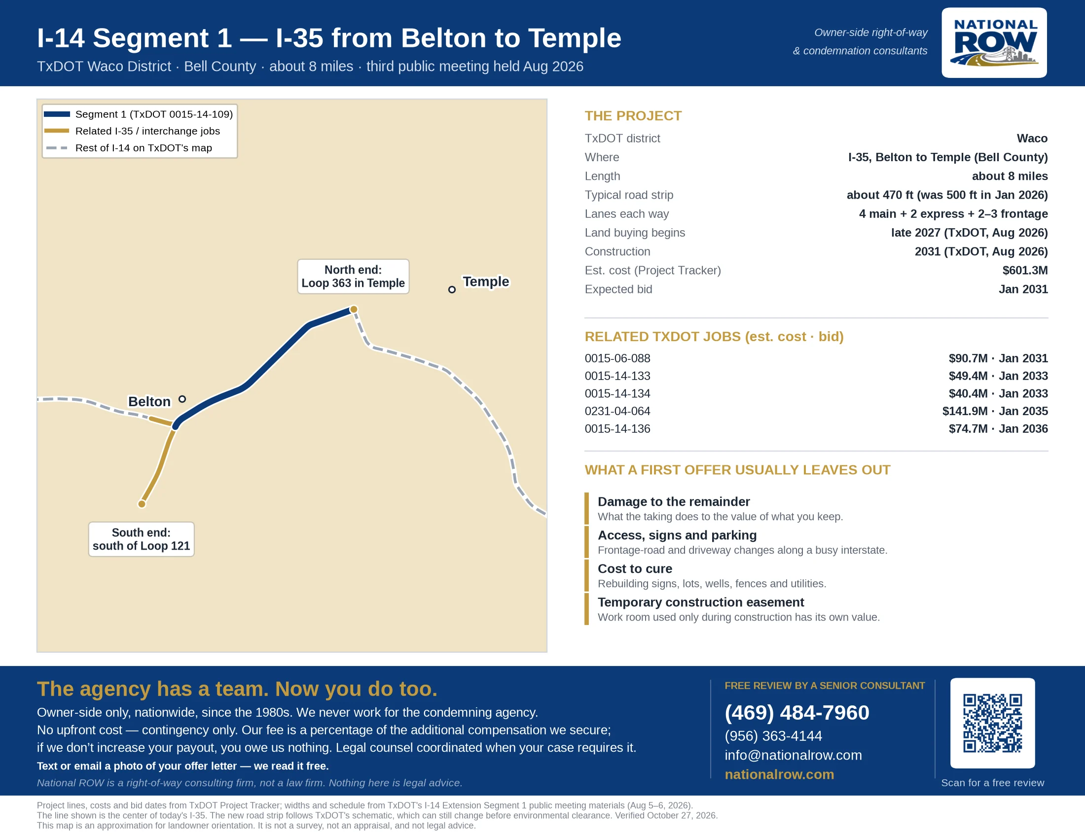
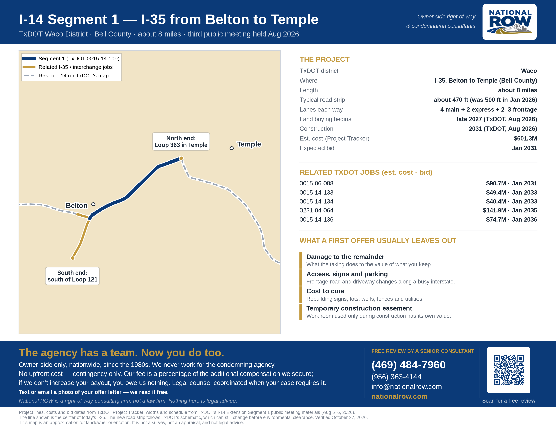
I-14 will be extended from Belton to Rogers in three pieces. Segment 1 is the first: about 8 miles of I-35 from south of Loop 121 in Belton to Loop 363 in Temple, with new interstate interchanges and a flyover. TxDOT's plan adds lanes and frontage-road changes along a road lined with homes and businesses, and its August 2026 timeline starts land buying in late 2027. Below: where the project runs, what changed in August, the TxDOT jobs involved, and what a first offer on a highway taking usually leaves out.
Almost every condemnation case is a fight about a number, not about the law.
Almost every condemnation case is a fight about a number, not about the law.
A photo of the offer is enough — a senior consultant reads it and tells you what we see.
Text (469) 484-7960 →Four documented matters, each traced from the original offer letter to final settlement — two utility easements and two highway condemnations, labelled on each. Not an average and not a prediction; when we look at yours and think the number is close to right, we tell you so. National ROW is a right-of-way consulting firm, not a law firm, and nothing here is legal advice.
| Official name | I-14 Extension: I-35 from south of Loop 121 in Belton to Loop 363/US 190/SH 36 in Temple (Segment 1) |
| Agency | Texas Department of Transportation, Waco District |
| Main TxDOT job (CSJ) | 0015-14-109, plus 5 related I-35 and interchange jobs listed below |
| County | Bell |
| Length | About 8 miles (TxDOT August 2026 notice) |
| What gets built | Four general lanes each way (one more than today), two non-tolled express lanes each way, two to three frontage-road lanes, a shared-use path, rebuilt I-14/US 190/I-35 interchanges and a flyover to Loop 363 |
| Typical road strip | About 470 feet (cut from about 500 feet after the January 2026 meetings) |
| Public meetings | May 2024, January 2026, August 5–6, 2026 (comments closed August 21, 2026) |
| Land purchases (TxDOT timeline) | Begin late 2027 after environmental clearance, continuing into summer 2028 |
| Construction (TxDOT timeline) | 2031, depending on environmental clearance and funding |
| Project Tracker estimate | $601.3M for the main job, bid expected Jan 2031 |
| Land parcels on TxDOT's right-of-way map | None being bought yet, as of October 27, 2026 |
| TxDOT Waco District | (254) 867-2700 · 100 South Loop Dr., Waco |
Also searched as: I-14 Segment 1, I-14 extension Belton Temple, I-35 widening Belton to Temple, I-35 Loop 363 flyover, I-14 I-35 interchange Belton.
A one-page map of Segment 1 and the related I-35 jobs, with TxDOT's widths and schedule, drawn from TxDOT's own project data. Print it, take it to your appraisal district, or send it to whoever is advising you.
Segment 1 is one piece of Interstate 14. See every I-14 route in Texas, and the TxDOT jobs scheduled on each.
Enter an address to see roughly how far it sits from the center of I-35 in the Segment 1 project.
Tell us about your property. A senior consultant reads every one of these and calls you within the hour, 8am–6pm Central, Monday to Friday. Outside those hours, first thing the next morning.
Your case is in review. A senior consultant reads everything you shared and calls you within the hour, 8am–6pm Central, Monday to Friday. Outside those hours, first thing the next morning.
In the meantime, don't sign anything and don't feel pressured to respond to their representatives.
TxDOT held its third round of Segment 1 meetings in Temple on August 5 and Belton on August 6, 2026. It said the changes came from what owners and the community raised in January.
| January 2026 design | August 2026 design | |
|---|---|---|
| Express lanes | Six (three each way) | Four (two each way) |
| Typical road strip | About 500 feet | About 470 feet |
| Land needed | — | About 26 acres less, nearly 15% (TxDOT estimate) |
| Flyover to Loop 363 | Higher design speed, wider curve | Lower design speed, tighter curve, fewer neighborhood impacts |
Segment 1 is TxDOT job 0015-14-109. These related I-35 and interchange jobs sit on the same stretch. All figures are from TxDOT's Project Tracker on October 27, 2026; bid dates are estimates and move often.
| TxDOT job | Where / what | Status | Est. cost |
|---|---|---|---|
| 0015-14-109 | US 190 IN BELTON to S LP 363 IN TEMPLE Widen Road - Add Lanes | Bid Jan 2031 | $601.3M |
| 0015-06-088 | 1.16 Miles South of SL 121 to US 190 Widen Road - Add Lanes | Bid Jan 2031 | $90.7M |
| 0015-14-133 | WB US 190 to SB IH 35 Interchange Improvement (New Or Update) | Bid Jan 2033 | $49.4M |
| 0015-14-134 | NB IH 35 to EB US 190 Interchange Improvement (New Or Update) | Bid Jan 2033 | $40.4M |
| 0231-04-064 | IH 14 to IH 35 Interchange Improvement (New Or Update) | Bid Jan 2035 | $141.9M |
| 0015-14-136 | US 190 IN BELTON to S SL 363 IN TEMPLE Widen Road - Add Lanes And Shoulders | Bid Jan 2036 | $74.7M |
Segment 2 follows Loop 363 around Temple and is still in early planning. Segment 3 runs from SH 95 in Temple to BU 190 in Rogers, planned as frontage roads and overpasses along US 190. TxDOT's Segment 3 jobs in Project Tracker:
| TxDOT job | Where / what | Status | Est. cost |
|---|---|---|---|
| 0185-01-040 US 190 · Bell County | SL 363 to .3 MI N N190J Highway Improvement | Bid Jan 2037 | $37.6M |
| 0185-01-044 US 190 · Bell County | S190J to Rogers Bypass Highway Improvement | Bid Jan 2037 | $153.1M |
| 0185-05-001 US 190 · Bell County | FM 93 to S190J Highway Improvement | Bid Jan 2037 | $61.2M |
| 0185-05-004 US 190 · Bell County | 0.3 Mi N of N190J to FM 93 Highway Improvement | Bid Jan 2036 | $41.9M |
| 0320-01-075 US 190 · Bell County | SP 290 to SL 363 Highway Improvement | Bid Jan 2037 | $174.4M |
Send us the TxDOT letter, the plat, or just your address. We will tell you where your property sits against the project and what happens next.
Free review by a senior consultant →Or call or text (469) 484-7960 — a senior consultant answers owners the same day.
Tap any step to see what happens.
Three rounds of public meetings on the schematic. Comments on the August round closed August 21, 2026.
TxDOT expects to finalize the schematic in late 2027. A formal public hearing and TxDOT's environmental decision come before land buying starts.
TxDOT surveys the exact strip it needs from each property and hires an appraiser to value it. This appraisal becomes the base of the offer, so what it leaves out is what the offer leaves out.
Texas law requires a written initial offer with the appraisals TxDOT has from the last ten years, and the Landowner's Bill of Rights. TxDOT must wait at least 30 days before making a final offer.
The final offer must be at least TxDOT's own written appraisal, with the Bill of Rights sent again at least seven days before. You get at least 14 days to respond.
If you cannot agree, TxDOT files a condemnation case and a judge appoints three local landowners as special commissioners, who hear both sides and set an amount.
Either side may object to the commissioners' award and take the amount to court.
When TxDOT's offer arrives it comes as a package: a cover letter, the appraisal or a summary of it, a right-of-way map of the part TxDOT wants, and the Landowner's Bill of Rights.
| Component | What it pays for | Typically |
|---|---|---|
| Value of the part acquired | The strip itself, priced against comparable sales | Largest single line |
| Damages to the remainder | Lost value to everything you keep — shape, access, frontage, visibility, use | Frequently understated |
| Cost to cure | What it costs to fix what the taking broke — signs, parking, driveways, utilities, fences | Frequently omitted |
How much does the back half matter? In one recent Texas highway offer package our team reviewed, damages to the remainder made up about 39% of the total offer and cost to cure another 29%. Nearly seven of every ten dollars came from something other than the raw land price.
TxDOT's appraiser works for TxDOT. That does not make them dishonest — it makes them the other side's expert. These are the items that most often come in low or not at all on an urban interstate widening.
Tap each one to see what it means on your property.
A shallower lot, a building closer to the frontage road, a parcel that no longer fits its best use. What you keep is worth something different afterward.
Losing even a row of parking or a truck turning area can make a business site work worse than the square footage suggests.
A pylon sign that has to move, or a new wall or flyover that blocks the view from I-35, has real value to a business.
Driveways that close, move or become right-in, right-out change how customers reach you. Document how the site works today.
Water, sewer, power, fences, landscaping and paving inside the strip have to be replaced or moved, and that belongs in the offer.
Room TxDOT uses only during construction has its own value, for the time it is actually used.
Send it over with the appraisal if they gave you one — a photo of the pages is enough. A senior consultant will tell you what we see.
Free review by a senior consultant →Or call or text (469) 484-7960 — a senior consultant answers owners the same day.
We are on the owner's side of the right-of-way. We are paid out of the increase, which means we do not get paid unless you do better.
Send us whatever they sent you — a survey permission form, a letter, an appraisal, an offer. We read it and show you what it does and does not account for. No charge, no obligation.
We bring in independent, certified appraisers to value the part acquired and, critically, to document damages to the remainder and cost to cure.
We deal with the land agents and their appraisers directly, with documentation behind every number, so you are not negotiating alone against people who do this full time.
Our fee is a percentage of the increase above the original offer. If we do not improve it, you owe us nothing.
Tap any question to see the answer.
It is the first of three pieces that carry I-14 from Belton to Rogers. Segment 1 rebuilds about 8 miles of I-35 from south of Loop 121 in Belton to Loop 363, US 190 and SH 36 in Temple, including the I-14, US 190 and I-35 interchanges. I-14 will run along I-35 here, so this I-35 widening is also the I-14 extension.
Very possibly, if you are along I-35 between Belton and Temple. TxDOT's August 2026 schematic shows a typical road strip of about 470 feet, wider than today's, plus more land at the interchanges and the flyover to Loop 363. Your exact strip is shown on TxDOT's roll plots, which are linked in the sources below. Being close to the road does not by itself mean a taking; the roll plots show who is affected.
TxDOT's August 2026 timeline says land buying would begin in late 2027, after environmental clearance, and continue into summer 2028, with utility moves from 2028 to 2030 and construction starting in 2031. TxDOT says this depends on the environmental process and funding. Project Tracker expects the main job to bid in Jan 2031. As of October 27, 2026, TxDOT's public right-of-way parcel map shows no parcels being bought yet on the Segment 1 jobs.
After owners and the community raised concerns at the January 2026 meetings, TxDOT cut the express lanes from six to four (one fewer each way). That narrowed the typical road strip from about 500 feet to about 470 feet and, by TxDOT's estimate, cut the land needed by about 26 acres, nearly 15%. TxDOT also lowered the design speed on the flyover to Loop 363 so it can use a tighter curve with fewer impacts on the neighborhood next to it.
The comment period for the August 2026 meetings closed on August 21, 2026. A formal public hearing comes before environmental clearance; TxDOT had not announced a date as of October 27, 2026. You can still contact the Waco District at (254) 867-2700, and what you tell TxDOT's right-of-way staff later still matters.
On a busy interstate the land under the strip is often the smaller number. Lost parking, a sign that has to move, a driveway that closes or moves, and a change in how customers reach you can cost far more. Those are damages and cure costs, and they have to be documented with how the property works today.
No. Texas law requires TxDOT to make a written initial offer, give you the Landowner's Bill of Rights, and wait at least 30 days before a final offer, which must be at least the amount of its own written appraisal. You then have at least 14 days to respond. Those offers are TxDOT's opening position, not the last word on what your property is worth.
No. National ROW is a right-of-way and condemnation consulting firm, and we represent property owners only, never the agency. We do the valuation and negotiation work. When a case needs a lawyer, we say so and coordinate with condemnation counsel.
The review is free. If you engage us, we work on contingency: our fee is a percentage of the increase above the original offer. If we do not improve it, you owe us nothing.
TxDOT posted the fact sheet, presentation, exhibit boards, environmental constraints map and 24 roll plots from the August 2026 meetings on its I-14 Extension page. The links are in the sources below. Roll plots 1 to 12 show the road strip block by block.
A TxDOT letter, survey request, appraisal or offer — whatever stage you are at, we will read it and tell you where it is weak. Free, and there is no obligation to go further.
Free review by a senior consultant →Or call or text (469) 484-7960 — we answer owners the same day.