 Right of Way · Eminent Domain &
Condemnation Consulting Firm
Call or text(469) 484-7960
Emailinfo@nationalrow.com
Right of Way · Eminent Domain &Got a TxDOT letter or a survey request? Call or text (469) 484-7960Status checked October 27, 2026 against TxDOT's own records
Between Rogers in Bell County and Huntsville in Walker County, I-14 has no route yet. TxDOT's Bryan District is running a long study to find one, and in August 2026 it showed 17 conceptual routes, each about a mile wide, across 8 counties. Being inside a route does not mean your land will be taken: a finished interstate needs only 300 to 500 feet of it, and TxDOT says it is too early to know. Below: the routes on one map, an address check, and what the study means for owners.
Almost every condemnation case is a fight about a number, not about the law.
Almost every condemnation case is a fight about a number, not about the law.
A photo of the offer is enough — a senior consultant reads it and tells you what we see.
Text (469) 484-7960 →Four documented matters, each traced from the original offer letter to final settlement — two utility easements and two highway condemnations, labelled on each. Not an average and not a prediction; when we look at yours and think the number is close to right, we tell you so. National ROW is a right-of-way consulting firm, not a law firm, and nothing here is legal advice.
| Official name | I-14 Central Texas Corridor Study (TxDOT CSJ 0917-00-050) |
| Agency | Texas Department of Transportation, Bryan District |
| Study area | About 125 miles from Rogers in Bell County to Huntsville in Walker County, 11 counties |
| Conceptual routes | 17 routes, each about 1 mile wide, shown at the August 2026 open houses |
| Counties the routes reach | Brazos, Milam, Grimes, Burleson, Robertson, Walker, Madison, Bell |
| Route chosen | No |
| Next steps (TxDOT) | Narrow to a feasible route, then ~1,000-foot viable routes, then one preferred route in about 3 years; whole study 8–10 years |
| Construction funding | None identified (TxDOT FAQ, August 2026) |
| Comments | Round 3 comments closed October 12, 2026 (more than 1,300 received); next meetings expected in about 18 months |
| Study team | (979) 484-7358 · BRY_Interstate14Central@txdot.gov |
Also searched as: I-14 route Rogers to Huntsville, I-14 Central Texas Corridor Study, I-14 route map Cameron Hearne Bryan, Loop I-214 Bryan College Station, I-14 conceptual routes.
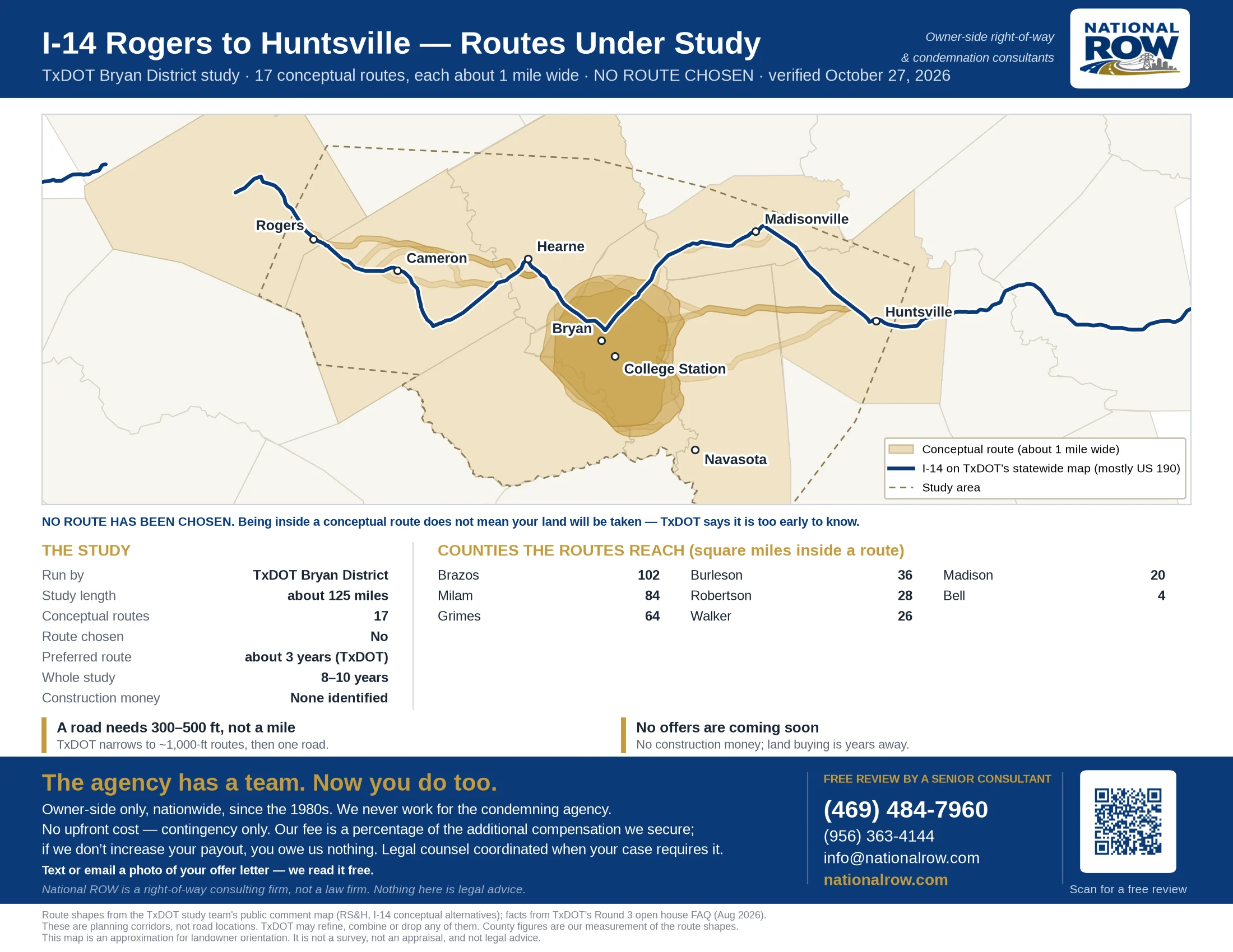
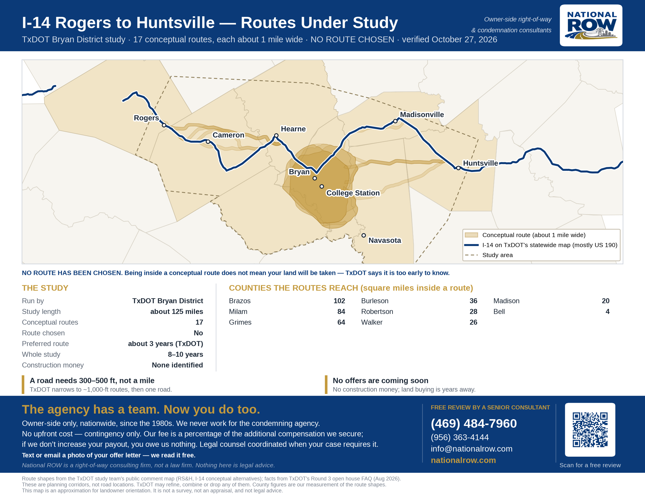
A one-page map of all 17 conceptual routes from TxDOT's August 2026 open houses, with the counties they reach, drawn from the study team's own route shapes. No route has been chosen.
This study covers one stretch of Interstate 14. See every I-14 route in Texas.
Enter an address to see whether it falls inside one of TxDOT's conceptual routes, and how far it is from the nearest one.
Tell us about your property. A senior consultant reads every one of these and calls you within the hour, 8am–6pm Central, Monday to Friday. Outside those hours, first thing the next morning.
Your case is in review. A senior consultant reads everything you shared and calls you within the hour, 8am–6pm Central, Monday to Friday. Outside those hours, first thing the next morning.
In the meantime, don't sign anything and don't feel pressured to respond to their representatives.
Each route TxDOT showed in August 2026, the counties it reaches, and its size. County lists and square miles are our measurement of the route shapes against Census county lines.
| Route | Counties it reaches | Sq. miles |
|---|---|---|
| Central 1 | Grimes, Robertson, Burleson, Brazos | 83 |
| Central 2 | Grimes, Robertson, Burleson, Brazos | 81 |
| Central 3 | Robertson, Burleson, Brazos | 69 |
| Central 4 | Grimes, Robertson, Burleson, Brazos | 78 |
| Central 5 | Robertson, Burleson, Brazos | 74 |
| Central 6 | Grimes, Robertson, Burleson, Brazos | 79 |
| Central 7 | Burleson, Brazos | 7 |
| East 1 | Grimes, Walker, Brazos | 35 |
| East 2 | Grimes, Walker, Brazos | 37 |
| East 3 | Grimes, Walker | 31 |
| East 4 | Grimes, Walker, Brazos | 38 |
| East 5 | Madison, Brazos | 24 |
| West 1 | Robertson, Milam, Bell | 41 |
| West 2 | Robertson, Milam, Bell | 42 |
| West 3 | Robertson, Milam, Bell | 41 |
| West 4 | Robertson, Milam, Bell | 43 |
| West 5 | Robertson, Milam, Bell | 45 |
All routes together cover about 366 square miles. Some routes overlap, so a property can sit inside more than one.
Send us your address or parcel number. We will tell you which routes it sits in, what the study means for you, and what to keep an eye on.
Free review by a senior consultant →Or call or text (469) 484-7960 — a senior consultant answers owners the same day.
TxDOT's FAQ lays out the steps. The study started with an area of about 5,000 square miles and works down in stages:
| Step | Width | Where it stands |
|---|---|---|
| Opportunity areas | Broad areas | Done |
| Conceptual alternative routes | About 1 mile | Shown August 2026 — now |
| Feasible route | Narrowed from the concepts | Next |
| Viable routes | About 1,000 feet | Later in the study |
| Preferred route | About 1,000 feet | About 3 years out (TxDOT) |
| Road design and right-of-way | Typically 300–500 feet | After the study, if funded |
A new interstate on new ground is different from widening a road that is already there. Instead of a strip off the front, it can cut across a ranch or farm, split a tract into pieces, and leave parts with no road access of their own. Those effects are where most of the value in a highway case sits.
An interstate controls access. Land on the far side of a new interstate may only be reachable by a frontage road or a crossing miles away. What the pieces you keep are worth, and what it costs to make them work again, belongs in any offer.
Texas valuation is supposed to set aside the effect of the project itself on the land TxDOT takes. Planning maps that sit on a property for years can make that harder to untangle, which is one reason to keep records of sales, listings and inquiries now.
We are on the owner's side of the right-of-way. We are paid out of the increase, which means we do not get paid unless you do better.
Send us whatever they sent you — a survey permission form, a letter, an appraisal, an offer. We read it and show you what it does and does not account for. No charge, no obligation.
We bring in independent, certified appraisers to value the part acquired and, critically, to document damages to the remainder and cost to cure.
We deal with the land agents and their appraisers directly, with documentation behind every number, so you are not negotiating alone against people who do this full time.
Our fee is a percentage of the increase above the original offer. If we do not improve it, you owe us nothing.
Tap any question to see the answer.
No. As of October 27, 2026, TxDOT has not chosen a route. The 17 routes shown at the August 2026 open houses are conceptual alternatives, and TxDOT says all of them remain under consideration.
Not necessarily, and TxDOT says it is too early to know. Each conceptual route is about a mile wide. TxDOT plans to narrow them to one feasible route, then to routes about 1,000 feet wide, then to one preferred route. A finished interstate typically needs 300 to 500 feet of right-of-way, so most land inside today's routes would not end up under the road.
TxDOT's FAQ says a preferred route could be identified in about three years, and that the whole study will take about 8 to 10 years. TxDOT told KBTX in October 2026 that it expects the next round of public meetings in about 18 months, with narrowed or changed route options.
Not soon. TxDOT says no construction funding has been identified, no road alignment has been drawn, and no right-of-way needs have been decided. Land buying would come only after a preferred route, an environmental study, a design and funding, which is years away.
TxDOT says no decisions about acquiring land have been made. If a later phase needs land, TxDOT would follow state and federal law, which includes a written offer, the Landowner's Bill of Rights and, if there is no agreement, a condemnation case.
It could in places. TxDOT is studying routes that use existing roads, new routes, or a mix, and it says US 190 is being considered but not every alternative follows it. The study also includes Loop I-214 around Bryan and College Station.
The comment period for the August 2026 open houses closed on October 12, 2026; TxDOT says it received more than 1,300 comments. You can still reach the study team at (979) 484-7358 or BRY_Interstate14Central@txdot.gov, and the next round of meetings is the next formal chance.
Keep every letter from TxDOT or its consultants, note the conceptual route your land is in, and watch for the next round of meetings. If someone asks to survey your land or offers to buy it, read what you are asked to sign before you agree. It costs nothing to have us look at it.
No. National ROW is a right-of-way and condemnation consulting firm, and we represent property owners only, never the agency. We do the valuation and negotiation work. When a case needs a lawyer, we say so and coordinate with condemnation counsel.
The review is free. If you engage us, we work on contingency: our fee is a percentage of the increase above the original offer. If we do not improve it, you owe us nothing.
A TxDOT letter, survey request, appraisal or offer — whatever stage you are at, we will read it and tell you where it is weak. Free, and there is no obligation to go further.
Free review by a senior consultant →Or call or text (469) 484-7960 — we answer owners the same day.